Doherty Smith & Associates is now Compass Consulting Surveyors
Click here to see more articles on our new website compasscs.com.au
- Electronic plan lodgement, or eplan, has been available in NSW for over 10 years, and allows plans to be lodged via a portal to Land and Property Information NSW (LPI NSW). Eplan users create a digital version of a plan, scan associated documents such as administration sheets, Section 88B instruments and checklists then package all files together for lodgement.
- Typically, for a plan to be prepared, the data, consisting of lines, parcels and text, is extracted to produce the plan. The plan is then used to present the data in a traditional format, with the lines, parcels and text no longer accessible as “smart” entities.
- The format adopted for documents under the eplan scheme is for all documents to be created or saved as a TIF image file. In order for any information on these image files to be used, it must be extracted manually. In terms of the plan, future users must read the plan and manually enter the dimensions from the plan to another software package. This means that when a plan of subdivision is lodged, many different users including LPI, local councils and utility providers must then manually enter the information shown on the plan. Manual data entry is prone to errors, and often large amounts of data must be double checked to ensure the accuracy of the end result.
- Plans lodged by Eplan as TIF files or by manual lodgement typically take between 3 and 6 weeks to be registered. If there is a legitimate reason to ask for expediency, a request can be lodged with the plan, which can reduce the time for registration significantly. It is not possible to request urgency on every plan lodgement.
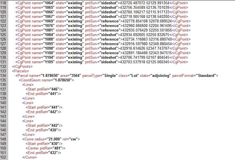
- In recent years, LPI NSW have been developing a new form of plan which retains the lines, parcels and text as entities which can be used directly, without the need for manual data entry. In order for the data to be an entity, the plan must be a digital file which contains not only the graphical element of traditional plans, but also the “smart” entities which make up the plan. The chosen format for plans is called XML, or LandXML.
- Without going into great detail, Land XML format contains the dimensions for parcels, lines and curves as well as text notations. Land XML format is an international standard format for transferring land boundary (or other) data. NSW LPI have adopted the international standard in general terms, customising some data fields as necessary.
- Plans prepared using XML format differ from traditional paper plans. The “plan” itself is a data file, from which a rendering of the paper plan can be produced. The benefits of XML Eplan include time saved in data entry, reduced (or eliminated) errors due to manual data entry and faster processing times for plan registration. When ordering a plan, both the rendered or TIF version and the XML version are provided. This allows the end user to import the “smart” data directly to in-house software.
- For surveyors, preparing a plan in XML format represents a new challenge. Current surveying software is still at an early stage in terms of producing a useable XML data file. The future model for XML plans is that the plan itself will be “rendered” or drawn via a rendering engine on the Land and Property Information NSW website. This will eliminate the need for a surveyor to prepare both a drafted plan and an XML file. At present, the rendering engine is not sophisticated enough to allow any plans other than the most simple plans to be rendered to a standard sufficient for registration.
- The inability for the rendering engine to produce a registrable copy of the plan means that the main advantage for XML plans is the registration time. Official figures for registration of XML plans is between 2 and 9 days. This is dependent on all accompanying documentation being correct and available. For example, the certificate/s of title for the land must be produced at the Land Titles Office prior to or very soon after the plan is lodged. Any delays caused by errors in accompanying documentation or lack of title availability will cause the registration of the plan to be delayed.
- XML plan lodgement has been slow to be adopted by surveyors. This is largely because of difficulties in extracting a uesable XML file directly from proprietary surveying software such as Magnet Office. At the end of 2014, approximately 65 plans had been lodged by XML eplan.
In future, paper plans and manual plan lodgement are likely to be phased out. Based on the current technology, it is not economically feasible to adopt XML eplan for all plan lodgements, due to the fact that the plan must be prepared twice, once as a “fair drawn” plan for paper or TIF lodgement, and once as an XML file. Doherty Smith & Associates offer XML plan lodgement as an added service and are finding many clients are happy to adopt XML lodgement in order to achieve a fast registration time. Please contact us if you have any queries.
Eric Smith
Registered Surveyor


