

Doherty Smith & Associates is now Compass Consulting Surveyors
Click here to see this blog and more on our new website compasscs.com.au
“Throw or keep?”
We were cleaning out the back room of our survey office, almost the equivalent of an archaeological dig.
“Keep, might be useful some day.”
Then: “Oh Wow!”
And there is was, a dusty old document on faded paper, giving us an insight into the changes thrust upon surveyors in 1972.
In Australia we have adopted the metric system and measure distances in metres, or variations thereof, measure weights in kilograms, volumes in litres, temperatures in decimal degrees and speeds in kilometres per hour. We now take it for granted, and most of us have grown up only knowing these units.
As surveyors, we have to deal with plans dating from before the introduction of Metrication. Originally, survey plans were prepared in Links and Chains. One Link is 0.201168 metres and 100 links make a Chain of 20.1168 metres in length. Areas were notated in Acres, Roods and Perches, where there are 4 Roods to an Acre and 40 Perches to a Rood. The good thing for surveyors today is that converting Links to Metres is a straight conversion by applying the scale factor 0.201168.
Some later plans adopted feet and inches, which most of us will have some knowledge of, even if it is just an idea of their height in feet and inches. In terms of surveying and conversion to metres, feet and inches make conversion to metres more complicated. One foot equates to 0.3048 metres, while one inch equates to 0.0254 metres. Most survey plans showed distances to fractions of an inch, which then require conversion to decimal inches before conversion to metres. Another problem faced when reading plans in feet and inches is the quality of the reproduction of the plan. Annotations for fractions of an inch are often quite small and become hard to read on old scanned documents.
In 1972, the NSW Registrar General’s Department issued a document on Metrication. This document sets out the requirements for the preparation of plans in the metric standard of length.
Something that many people may not realise, is that Metrication changed almost everything in some way. One example is paper sizes. The Metric system uses international standards of paper sizes and the Metrication document introduced surveyors to three sizes of paper:
A2 (420mm x 594mm)
A3 (297mm x 420mm)
B3 (353mm x 500mm)
Interestingly, the A4 size (210mm x 297mm) was not mentioned.
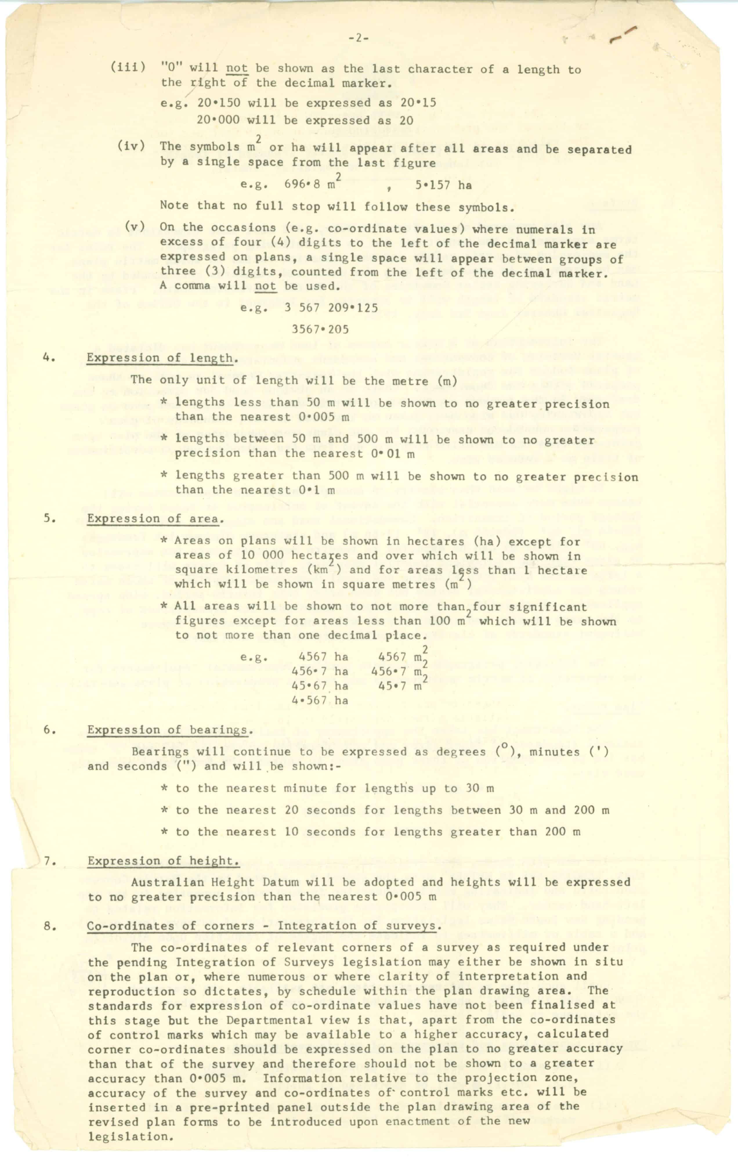
The Metrication document went on to describe the rounding required in the preparation of plans. This system, although no longer part of the directions for plan preparation, is still widely used today for clarity and consistency of plans. Lengths were to be rounded as follows:
Lengths less than 50 metres will be shown to no greater precision than the nearest 0.005 metres (5mm).
Lengths between 50 and 500 metres will be shown to no greater precision than the nearest 0.01 metres (10mm).
Lengths greater than 500 metres will be shown to no greater precision than the nearest 0.1 metres (100mm).
Bearings were required to be shown in degrees, minutes and seconds, which is still in use today. Bearings were to be rounded as follows:
For lengths up to 30 metres, bearings to be rounded to the nearest minute.
For lengths between 30 metres and 200 metres, bearings to be rounded to the nearest 20 seconds.
For lengths greater than 200 metres, bearings to be rounded to the nearest 10 seconds.
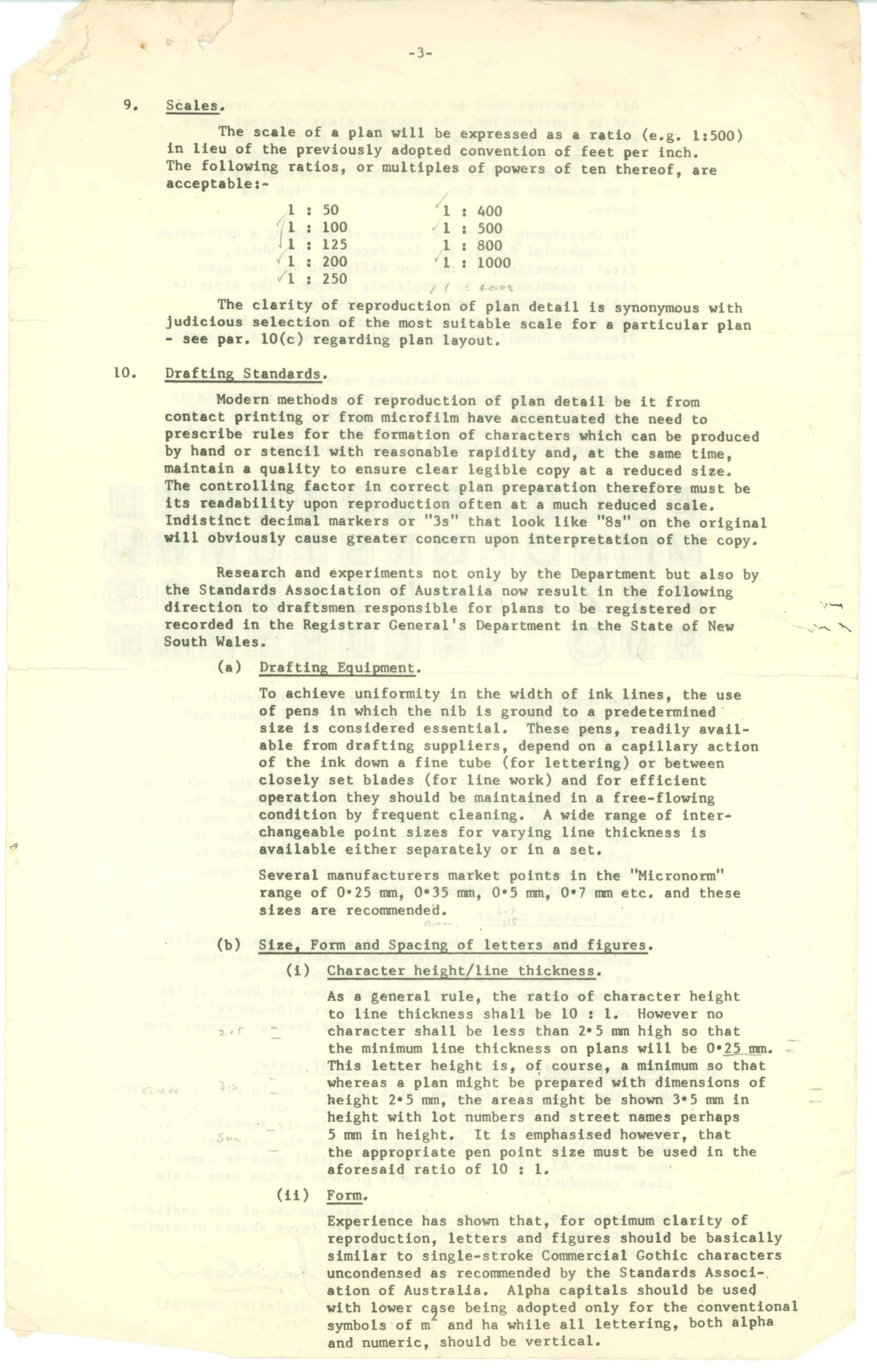
Standard scales for plans were introduced to replace the old system based on the number of feet represented per inch on the plan. Standard scales to be adopted were listed as follows:
1:50 1:400
1:100 1:500
1:125 1:800
1:200 1:1000
1:250
These scales, or factors of ten thereof, are still adopted for most survey plans today.
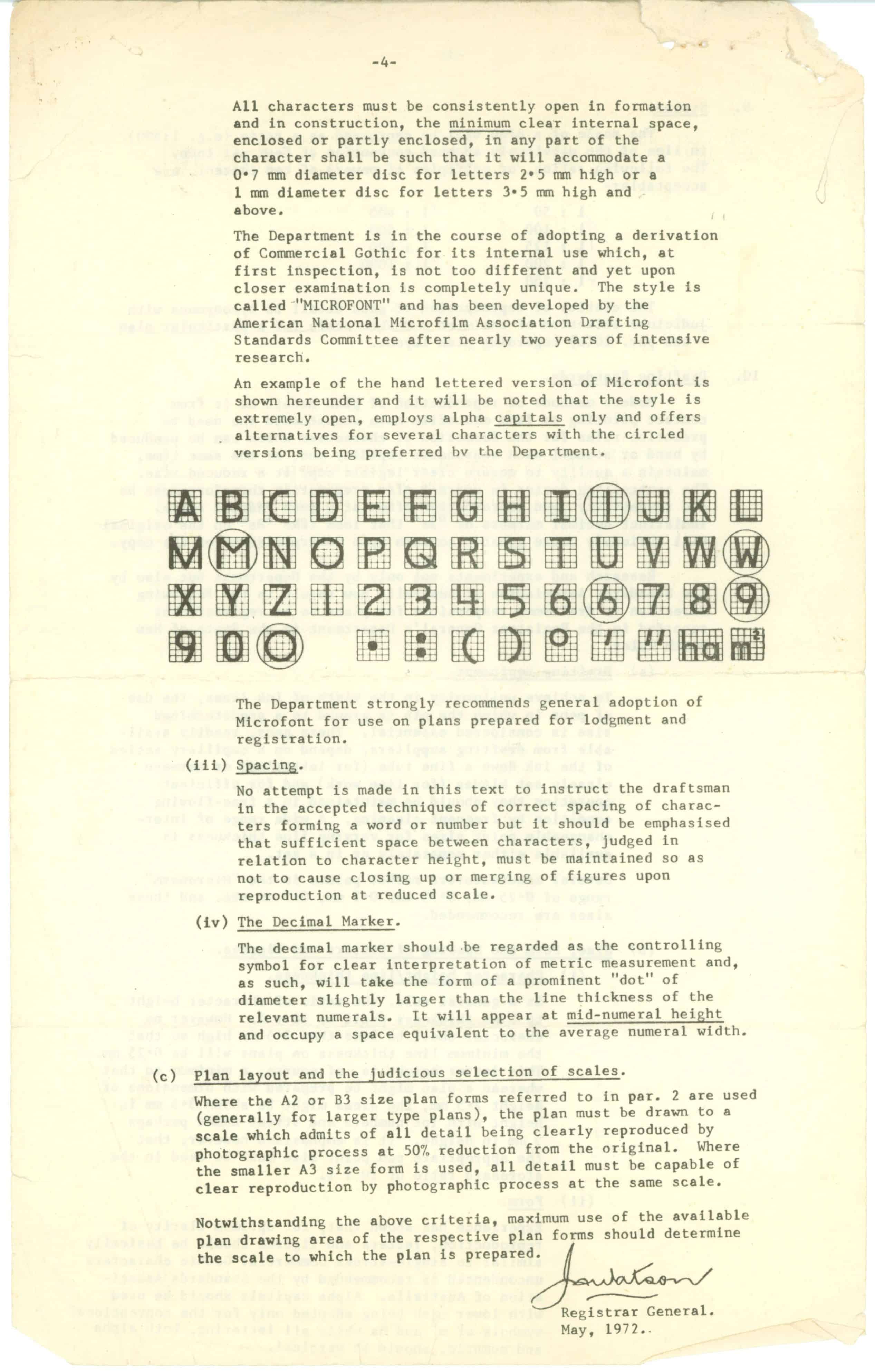
The Metrication document goes on to set out the standards for drafting of plans, including the equipment required, character size and even setting out the form of letters and numbers to be used, based on the “Microfont” style.
The full document is shown below.

Eric Smith
Surveyor Registered Under the
Surveying and Spatial Information Act 2002