

Doherty Smith & Associates is now Compass Consulting Surveyors
Click here to see this blog and more on our new website compasscs.com.au
The survey is complete, and in the mail you find an envelope. When you open the envelope you discover a report and a plan, covered in numbers, lines, text and symbols. You can make out the shape of your land, but a lot of the information shown is beyond your grasp. After some head scratching, and careful re-reading of the report, you decide that the surveyor has done a good job and immediately pay the account (well, ok, surveyors have dreams too you know!).
So, how do you read a survey plan and understand what is shown?
The first thing to understand is the purpose of the plan. This will depend upon the type of survey which has been performed. For this exercise, we will look at two examples: a plan of subdivision and an identification survey.
Understanding a Plan of Subdivision
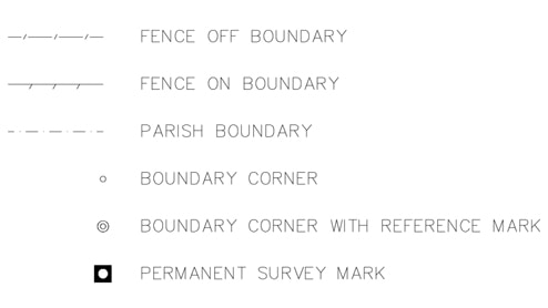
When preparing a plan of subdivision in NSW, a surveyor has to meet strict standards set out in the Registrar General’s Directions. The Directions specify what a plan must show and how it should be shown, and covers items such as the north point, methods of showing information, line thicknesses and many more. As if the Directions were not enough, the Surveying and Spatial Information Regulation 2012 also sets out conventional signs and symbols as well as more details on what should be shown on a plan of subdivision.
The plan will also show details such as lot numbers and areas. Adjoining land will also be labelled with the lot and DP (deposited plan) number, but will not show an area. A typical plan of subdivision will look a bit like this:
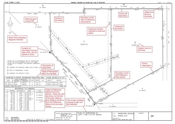
Much of the information shown is for statutory purposes and will be no direct use to a land owner.
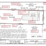
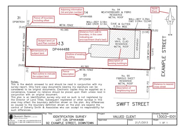
Understanding an Identification Survey sketch
When purchasing a property, it is recommended that an Identification Survey be performed – for more information see our blog on Identification Surveys. The Identification Survey will be presented to the client in the form of a report and attached sketch. We advise that the sketch forms a part of the report.
The purpose of an identification sketch is to show the improvements on the land in relation to the boundaries. The sketch is designed to be as easy to read as possible, showing the description of neighbouring land, distance from the nearest cross street (if there is one), description of the improvements on the land, and making clear any problems detected during the survey. In the example below, an encroachment by the house on the subject land upon the adjoining land has been indicated. Remember that an identification sketch is only valid when it bears the original signature of a registered surveyor.
Once you understand the basics of plan line and symbol conventions in NSW, plans can reveal more information to you. Of course, if you have further questions you should contact your friendly local surveyor.
Eric Smith
Surveyor Registered under the
Surveying and Spatial Information Act 2002