


Doherty Smith & Associates is now Compass Consulting Surveyors
Click here to see this blog and more on our new website compasscs.com.au
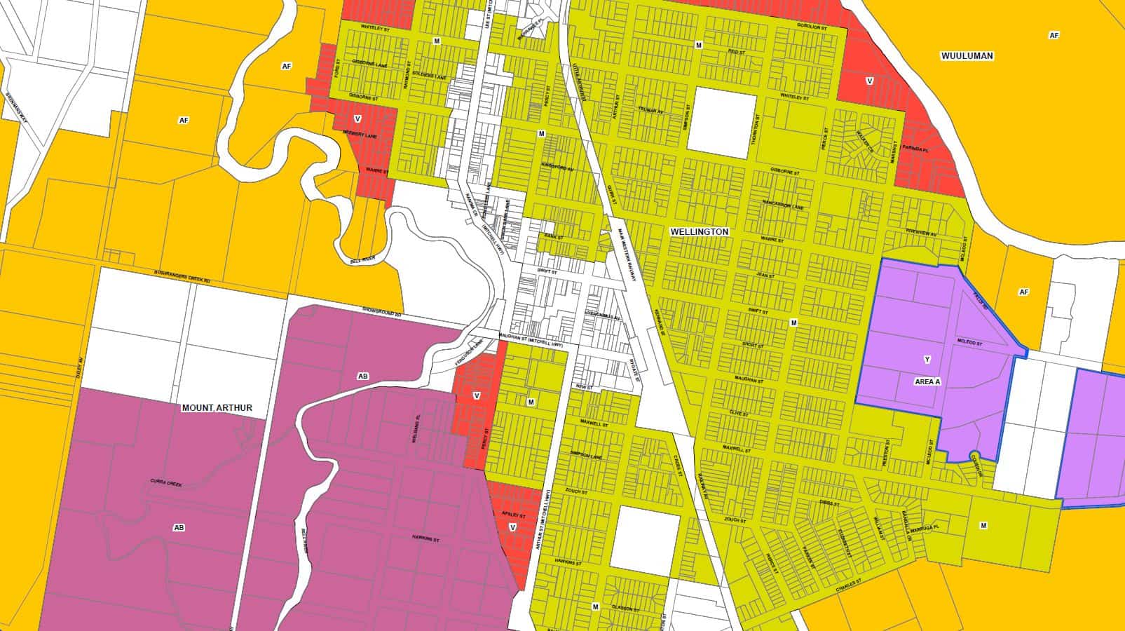
Typical Mimimun Lot Size mapping
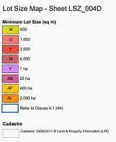
Legend for MLS mapping
What is a Minimum Lot Size and how does it affect dealings with land?
Under the current format for Local Environmental Plans, much of the relevant information on land is shown in maps. There is a set of maps showing the zoning for the entire Local Government Area, which is then cross-referenced with the written Instrument. The written instrument sets out the objectives of each zone, development which is permitted with or without consent and development which is prohibited.
Another set of maps shows the prescribed Minimum Lot Size for the entire LGA. Represented by varying colours on the map, the prescribed Minimum Lot Size for land indicates the minimum size for a newly created lot – with a few exceptions. But, what does it mean?
There are two factors to consider with the MLS and how it may affect any proposed development on the land: Firstly whether the lot is an existing lot or a newly created lot and how the size of the existing lot relates to the MLS. Secondly, whether the proposal is to create new lots, the size of any proposed lots and for what purpose they are created.
Considering an existing lot, with area in excess of the minimum lot size shown on the mapping, and in a Low Density Residential zone. Development permitted with consent in such a case includes construction and occupation of a dwelling on the land. If the lot does not meet the minimum lot size, no dwelling can be constructed on the lot. Furthermore, the land cannot be subdivided to create a lot of less than the minimum lot size.
Considering another case with an existing lot in a Rural (Primary Production) zone, with area less than the prescribed minimum lot size. Development permitted with consent, which may vary between LGA’s, usually includes primary industry related activities. Existing dwellings on the land are able to be occupied under Existing Use Rights – provided the occupation does not lapse for a period of 12 months or more (EP&A Act Clause 107 Sec (3)). If the land does not have a dwelling upon it, no new dwelling can be constructed.
The situation in rural zones is further complicated by Rural Subdivision clauses which have been adopted by some Councils. These clauses typically allow subdivision of land in rural areas, and may allow the creation of lots with area below the prescribed Minimum Lot Size, provided that no existing dwelling will be situated on a lot below the Minimum Lot Size after the subdivision, and that no dwelling could be constructed on a lot below the Minimum Lot Size.
Boundaries between existing lots where one or more of the lots have area below the Minimum Lot Size can be changed by way of boundary adjustment. Where the change is “minor”, the development may be considered exempt development (not requiring a development application) under the State Environmental Planning Policy (Exempt and Complying Development Codes) 2008. Where the change is not “minor”, development consent is required by the local Council.
Problems arise with the current system where the mapping is changed or created where existing lots are less than the Minimum Lot Size. This is particularly common in rural zones, where Minimum Lot Sizes reflect the size of agricultural holding which is considered adequate to be economically sustainable. This supposition that each lot is an independent agricultural holding does not reflect the historical system where most agricultural holdings are made up of multiple lots. The flexibility of this system allows farm adjustments to occur without subdivision. Under the current Minimum Lot Size system however, for a new dwelling to be constructed the lot must meet the Minimum Lot Size criteria. Subdivision of land can still occur if the LEP contains a clause allowing rural subdivision, as outlined above.
In other zones, particularly residential zones, when existing lots are less than the Minimum Lot Size, there are limited clauses to allow subdivision other than minor realignments of a boundary under the State Environmental Planning Policy (Exempt and Complying Development Codes) 2008. Subdivision of land is permissible only when the lot or lots being created are in excess of the Minimum Lot Size. This restriction prevents adjustments of boundaries which are larger than “minor” where lots do not meet the Minimum Lot Size.
To remedy a restrictive Minimum Lot Size, the only path currently available is via a planning proposal – an expensive and slow process. Where the LEP is under review, a submission can be made to request that consideration be given to changing a Minimum Lot Size while retaining the current zoning. This option is sometimes preferred by Councils to an application which also changes the zone, because the permitted land uses and objectives of the zone are retained.
There are other mechanisms which may allow boundary adjustments or subdivisions where the proposed lots do not comply with the Minimum Lot Size, which vary between Councils. In some LGA’s, for example, other types of subdivision including Community title or Strata subdivision may be allowable to create lots of less than the prescribed Minimum Lot Size. Many councils will approve a subdivision to create lots of less than a prescribed Minimum Lot Size under other clauses of their LEP. If you wish to change boundaries and are restricted by the prescribed Minimum Lot Size, contact your local consulting surveyor or town planner for specific advice.
Eric Smith
Registered Surveyor